As winter descends on the Heartland, staying informed about Indiana travel advisories and road conditions in Indianapolis becomes crucial for safe and efficient journeys. With the weather often unpredictable, keeping an eye on the latest updates can help travelers navigate the state’s highways and byways with confidence.
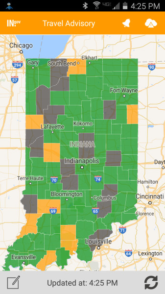
The Indiana Department of Homeland Security (IDHS) is a vital resource for travelers, providing an online travel advisory map that covers every county in the state. This map, accessible through the IDHS website, offers real-time updates on road conditions, traffic incidents, and weather-related hazards. The app is available for download on both Apple and Android devices, making it easy to stay informed on the go.
For those planning to travel through Indianapolis, the city’s traffic conditions are closely monitored by several sources, including the Indiana Department of Transportation (INDOT). The INDOT Trafficwise Map provides detailed reports on traffic incidents, road closures, and construction zones, ensuring drivers are well-prepared for any potential delays. This tool is invaluable for commuters and travelers alike, offering a comprehensive view of the current traffic landscape.
For a more localized perspective, the National Weather Service (NWS) provides detailed road report conditions specific to Indianapolis. Their website includes current hazards, weather forecasts, and radar updates, helping drivers anticipate any weather-related challenges. The NWS road reports are particularly useful during inclement weather, offering insights into conditions that could impact travel plans.
In addition to these resources, local news outlets and weather channels provide continuous updates on Indiana road conditions. Stations like WANE 15 and ABC Channel 6 offer interactive maps and real-time alerts, ensuring that travelers have the most current information at their fingertips. These resources are essential for planning routes and adjusting travel schedules as needed.
The current weather and road conditions in Indiana highlight the importance of staying informed. With much of the state under travel advisories, drivers need to be vigilant and prepared for potential hazards. The IDHS travel advisory map is a critical tool, using color-coded shadings to indicate the safety of travel in each county. Green areas signify normal travel conditions, while yellow, orange, and red zones indicate increasing levels of caution.
In conclusion, staying informed about Indiana travel advisories and road conditions in Indianapolis is essential for safe travel. By utilizing resources like the IDHS travel advisory map, INDOT Trafficwise Map, and NWS road reports, travelers can navigate the state’s roads with confidence. As winter continues, these tools will be crucial for ensuring safe and efficient journeys through Indiana.