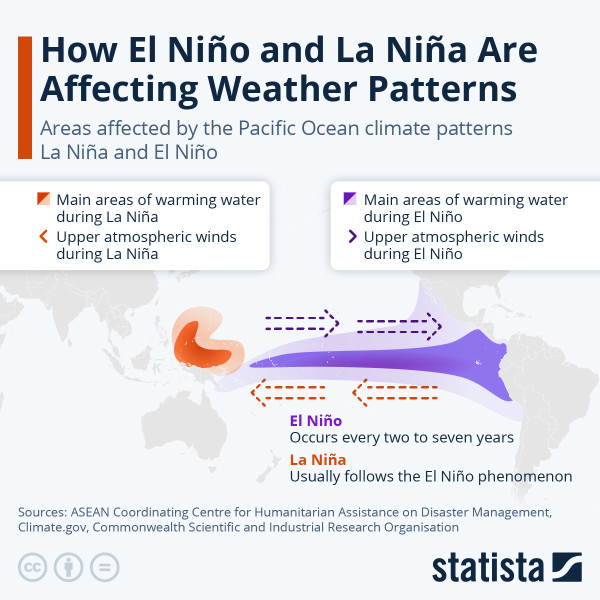
The **El Niño** forecast for 2026 is a critical topic of discussion among meteorologists and climate scientists. As of March 2026, the climate is transitioning from La Niña to an **ENSO-neutral** phase, and there are indications that a strong **El Niño** pattern may develop by the end of the year. This shift is significant because it can have far-reaching effects on global weather patterns, including temperature fluctuations and the severity of the hurricane season.
The **National Oceanic and Atmospheric Administration (NOAA)** has been closely monitoring the transition from La Niña to ENSO-neutral. La Niña conditions, characterized by below-average sea surface temperatures in the central and eastern tropical Pacific, have been persisting. However, there is a 75% chance that these conditions will transition to ENSO-neutral within the next few months. This transition is expected due to the weakening of subsurface temperature anomalies, which are crucial for maintaining La Niña conditions.
The **World Meteorological Organization (WMO)** and the **International Research Institute for Climate and Society (IRI)** are collaborating to provide regular updates on the El Niño-Southern Oscillation (ENSO) status. These updates are crucial for understanding the potential impacts of the upcoming El Niño. The WMO's El Niño/La Niña Update, prepared approximately every three months, leverages contributions from leading centers around the world monitoring and predicting these climate patterns.
NOAA's **Climate Prediction Center (CPC)** plays a pivotal role in forecasting these climate patterns. The CPC releases official updates on the second Thursday of each month, providing detailed insights into the current and expected states of the ENSO. These updates are based on various indicators, including sea surface temperatures (SST), out-going longwave radiation (OLR), the Southern Oscillation Index (SOI), and sea level anomalies.
For those interested in real-time data and measurements, the **National Weather Service (NWS)** provides a comprehensive list of resources. These include real-time TAO El Niño buoy data from the NOAA/PMEL TAO buoy network, which offers detailed information on the state of the ocean climate and ENSO indices. These tools are invaluable for researchers and meteorologists looking to stay updated on the latest developments in El Niño and La Niña conditions.
The implications of an upcoming El Niño are vast. A super **El Niño** could lead to increased temperatures globally, potentially affecting agriculture, water resources, and ecosystems. Additionally, the hurricane season could be influenced, with potential changes in the frequency and intensity of storms. As we move closer to the end of 2026, keeping an eye on these updates will be essential for preparedness and mitigation strategies.
The transition from La Niña to a potential strong El Niño in 2026 is a complex and dynamic process. With the combined efforts of organizations like the NOAA, WMO, and IRI, we can expect more detailed forecasts and updates. Staying informed about these changes will be crucial for understanding and adapting to the potential impacts of this significant climate phenomenon.