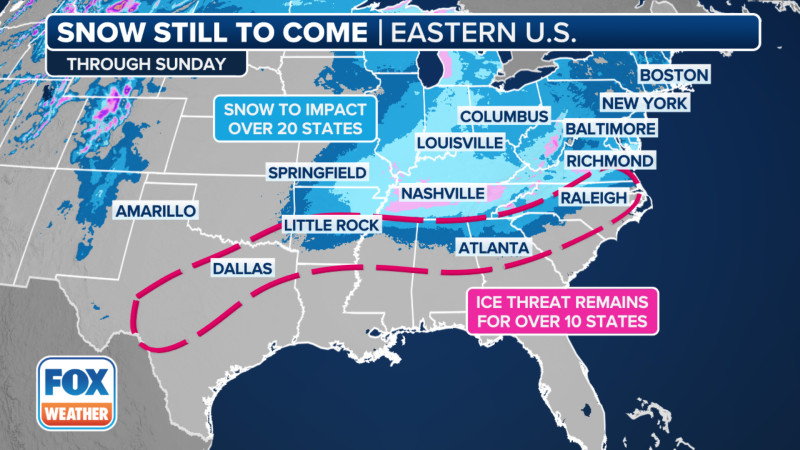
As of today, winter weather warnings are in effect across multiple states, prompting concerns for residents in the affected areas. The National Weather Service (NWS) has issued a series of alerts, including winter storm warnings and winter weather watches, signaling the potential for heavy snow, strong winds, and hazardous travel conditions.
According to the latest weather forecast, a major winter storm is expected to impact the Midwest, bringing significant snowfall and strong winds. The storm is anticipated to create dangerous travel conditions, with heavy snowfall and icy roads posing significant risks for drivers and travelers. Weather experts advise residents to stay informed and prepared for potential disruptions in daily activities.
Specific regions in the upper Midwest and Great Lakes are under the highest alert. The Weather Channel and other meteorological services have warned of heavy snow accumulations and strong winds that could make travel nearly impossible. Residents are advised to avoid unnecessary travel, as road conditions are expected to deteriorate rapidly. Areas in northern Minnesota are particularly at risk, with forecasts indicating a potential for more than a foot of snow starting late Thursday afternoon..
The NWS has also emphasized the importance of staying informed through their winter weather alerts and winter weather outlook. These alerts provide real-time updates on active warnings, expired alerts, and upcoming weather forecasts. Monitoring these alerts can help residents and travelers stay safe during the storm.
The current weather forecast indicates that the storm will bring a mix of snow, ice, and strong winds to the affected areas. With 13 states under winter storm warnings and advisories, residents from the Northern Plains to the Northeast are advised to take necessary precautions. The NWS urges everyone to stay informed about local conditions and adhere to the guidelines issued by local weather authorities.