Severe thunderstorm watch issued for Kansas City as storms approach
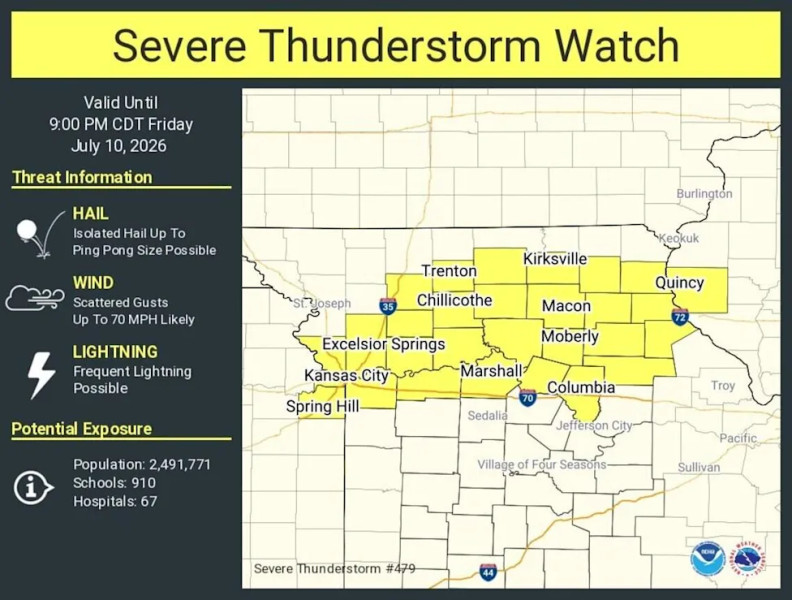
A severe thunderstorm watch covering Kansas City’s metro area warns of high winds, hail, possible tornadoes and flash flooding, prompting emergency officials to ready shelters and urge residents to stay indoors.
Key points
- The National Weather Service issued a severe thunderstorm watch for counties on both the Kansas and Missouri sides of Kansas City.
- Officials added a flood watch and are positioning emergency personnel and shelters for potential impacts.
- Residents are advised to monitor updates, avoid travel and follow instructions from emergency services.
Kansas City residents are on high alert as a severe thunderstorm watch has been issued, with meteorologists warning of potentially devastating weather conditions in the coming hours. The threat of storms, high winds, and possible tornadoes has the city bracing for impact.
Preparations Underway Across the Region
The Kansas City area is bracing for a severe thunderstorm watch, issued in recent times as the National Weather Service anticipates a dangerous mix of weather conditions. Residents have been warned about potential hail, strong winds, and even tornadic activity.
Local authorities have been preparing the city’s infrastructure and emergency services. According to the National Weather Service, the watch encompasses several counties in the Kansas City metro area, extending to both Kansas and Missouri sides of the region.
“It's critical that residents stay informed and take necessary precautions,” stated a spokesperson for the National Weather Service. “This storm system is particularly concerning, given its potential to produce tornadoes and other severe weather elements.”
Potential Impact and Safety Measures
Gone are the days when thunderstorms were just a minor inconvenience. This severe thunderstorm watch has prompted the city to issue a flood watch alongside the severe thunderstorm alert.
Residents are encouraged to monitor local weather updates and follow the instructions of emergency services. “We expect significant rainfall and potential flash flooding, so it's important for everyone to stay indoors and avoid driving if possible,” said a local emergency management official.
“Think again about how you prepare for storms,” another expert warned. “Severe thunderstorms are not to be underestimated. They can cause significant damage and pose serious risks to life and property.”
The power of nature is undeniable; the aftermath of such storms can be devastating. The potential for widespread power outages, downed trees, and flooded roads is high, and everyone is urged to stay vigilant and prepared.
In addition to the immediate dangers, the severe thunderstorm watch has raised concerns about the long-term impact on the region. The combination of heavy rainfall and strong winds could exacerbate existing weather conditions and cause secondary issues like landslides and structural damage.
Community Support and Emergency Response
The city’s emergency response teams are on high alert, with personnel stationed at key locations to provide immediate assistance. Community centers and schools are being converted into temporary shelters for those who may need to evacuate.
Local hospitals and medical facilities have also been preparing for an influx of patients, with extra staff and supplies on standby. The focus is on ensuring that everyone has access to the care they need, especially in light of the potential for injuries from falling debris or flooding.
NWS officials remind residents that during active watches and warnings, it’s imperative to stay tuned to reliable sources for updates. Severe weather can change rapidly, and staying informed can make a critical difference in safety.
“Nobody saw this coming,” one resident commented as they rushed to stock up on essentials. “But we’re all doing our best to be ready.”
With the severe thunderstorm watch in effect, the city is united in its preparations, knowing that the coming hours will test their resilience and readiness. The winds of change are blowing, and the community is bracing for whatever nature throws their way.
As the severe thunderstorm watch continues, emergency planners are also monitoring the potential for a severe thunderstorm warning, which would indicate that dangerous weather conditions are imminent. The distinction between a watch and a warning is crucial, as a warning signifies immediate danger and the need for immediate action.
As the weather turns increasingly dangerous, the community remains vigilant, hoping to weather the storm and emerge stronger on the other side.
Your questions, answered
What does a severe thunderstorm watch mean for Kansas City?
It means conditions are favorable for severe storms, including high winds, hail and possible tornadoes, and residents should stay alert.
Are there additional warnings besides the thunderstorm watch?
Emergency officials also issued a flood watch because of expected heavy rain and flash‑flooding risk.
Quick poll
How prepared do you feel for the severe thunderstorm threat in Kansas City?
0 votes
How does this story make you feel?
Topics
 Up next · WorldSaudi Arabia faces missile and drone attacks on airports